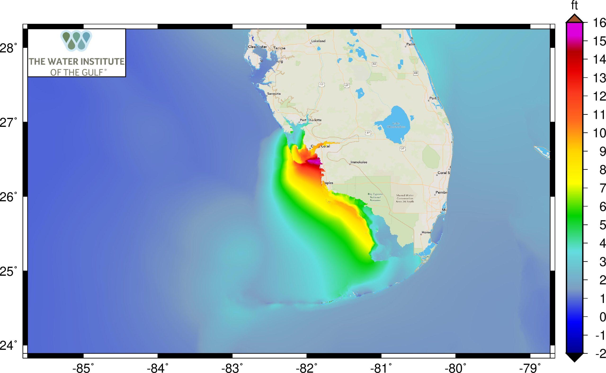
Peak water level simulated during Hurricane Ian by the ADCIRC model.
Timely predictions assist emergency efforts throughout state, federal responses
Hurricane Ian was a historically deadly hurricane. But fast storm surge predictions led by scientists at the University of North Carolina, Chapel Hill, and The Water Institute of the Gulf, running for the first time on PSC’s Bridges-2, gave accurate real-time predictions to emergency management decision makers. This aided them in evacuation and disaster-response decisions that may have saved lives.
WHY IT’S IMPORTANT
There’s no sugar-coating Hurricane Ian. With 147 known fatalities to date — 136 alone in Florida — it’s the deadliest on record for that state since the Labor Day hurricane of 1935.
It could have been worse. As the tropical depression that became Ian developed off the South American coast in September, a vast network of emergency and recovery services sprang into action at both the state and federal levels. Decision makers had hard choices to make: Where did people need to be evacuated? What support services would be affected by the storm and so not available to aid in the recovery? Where could relief efforts be safely staged so that they could launch immediately after the storm passed?
Officials at dozens of locations across the state and country needed the best information possible about the storm, local capabilities, and response resources. In particular, they needed to know where the storm would hit, what direction it would be coming from, and how powerful a punch it would pack.
Above all, they needed all of this in real-time, because a delay of even a couple of hours would be too late.
“FEMA has a group that does damage assessment using their Hazus software. They primarily make damage forecasts based on forecast winds. We have been working with them through our [Department of Homeland Security] Coastal Resilience Center to create a pipeline to get our ADCIRC storm surge and inundation forecasts into Hazus … Ian was our first opportunity to test that out in real time.” — Rick Luettich, UNC Chapel Hill
A storm surge prediction team led by Rick Luettich of the University of North Carolina, Chapel Hill, and Zach Cobell of The Water Institute of the Gulf in Louisiana rose to this challenge. Their tool of choice? PSC’s National Science Foundation-funded Bridges-2 supercomputer.
Simulated Hurricane Ian water levels as the storm approaches the Florida coast.
HOW PSC HELPED
The team had been honing their computer tools for simulating and predicting storms long before Ian. Using Bridges-2, and its predecessor Bridges, they had developed software that enabled them to take in storm data, process it, and distribute it via the cloud to stakeholders wherever they were.
Predicting a storm’s behavior in real-time presents a big challenge; the need for power in ingesting and crunching the data, and then getting it out to the people who needed it, would be a first-ever, real-time test of their latest methods. They’d need to jump onto Bridges-2 at a moment’s notice and have enough computing horsepower to get the job done.
Tom Maiden, PSC’s manager of user services, was pivotal in getting the team access to Bridges-2. Partly through an early research allocation via the NSF’s ACCESS system, in which PSC is a leading member, and partly through use of PSC’s “discretionary time,” allowed by the NSF for urgent projects, the team reserved some 2,000 of Bridges-2’s computing cores, running various storm surge and wave simulations about four times a day.
An important enhancement was the availability of Ian forecasts from the U.S. Navy’s tropical cyclone model, COAMPS-TC. The team hadn’t used it before, but as part of a National Ocean Partnership Hurricane Coastal Impacts project, they began to use these forecasts alongside forecasts from the National Hurricane Center and the National Weather Service to drive their ADCIRC storm surge/inundation model. For this storm, COAMPS-TC was a game changer. Its forecasted track proved much closer to the actual storm track that made landfall near Ft. Meyers, FL.
“Bridges-2’s connection out to AWS is extremely fast, and so we’re able to very rapidly get the data to stakeholders… [Also], because PSC has set us up with a dedicated virtual machine we were able to test the latest forecast system developments in the months leading up to an event like Ian. It’s exciting that in its first real time usage, we were able to deliver a product that was usable [by the stakeholders].” — Zach Cobell, The Water Institute of the Gulf
Just as importantly, Bridges-2 provided a seamless connection to Amazon Web Services (AWS), which aided the scientists in moving the data into the PSC machine and then out to the stakeholders. This meant that, every day between 9 and 10 a.m. leading up to the storm — quickly enough to enable real-time decision making — their storm surge and flooding predictions were on the desks of decision makers, from the US Coast Guard to the Secretary of Homeland Security in Washington, D.C., 700 miles away.
No weather model is perfect. It’s typical for one model to make a correct prediction with one storm, another model being correct for the next. Adding the capability to bring in the latest models, like COAMPS-TC and other available tropical cyclone forecast data, is valuable in helping decision makers understand the situation on the ground well enough to make the best determination. For Ian, the accuracy of COAMPS-TC was encouraging. The COAMPS-TC and ADCIRC models have been included in projects that have been funded as part of the Biden-Harris administration’s advancement of ocean science and technology through partnerships.
The group will continue offering predictions to decision makers. One major goal will be to continue improving the user interface that presents the findings in graphical ways to stakeholders and make them even quicker for decision makers to understand and act upon.
